
The Himalayas are often called the Roof of the World.
For thousands of years, these mountains have shaped rivers, civilizations, cultures, and life across South Asia.
But on August 26, 2026, the mountains became the starting point of a devastating chain of events.
High in the Himalayas near the Nepal–Tibet border, a massive section of glacier and rock collapsed.
What followed was not an ordinary flood.
Ice, rocks, mud, and water rushed down the Lhende River, eventually reaching river systems in Nepal.
Communities along the river corridor were hit by a sudden and destructive surge.
So what really happened?
Why did a collapse high in the mountains turn into a catastrophic flood hundreds of metres below?
And what does this disaster tell us about the changing risks in the Himalayas?
Watch the Full Nepal Flood Documentary
Watch the National Geo History documentary to explore the complete story behind the 2026 Nepal floods, from the high Himalayan collapse to the devastating flooding along the Trishuli River.
Explore the evidence, geography, science, and unanswered questions behind one of Nepal’s most devastating recent disasters.
Full Video
What Happened in the Himalayas?
The disaster began high above the settlements of northern Nepal.
According to reporting based on satellite imagery and official information, a substantial section of a glacier broke away at an elevation of approximately 5,200 metres.
The falling ice and rock plunged roughly 1,200 metres toward the valley below.
As the enormous mass descended, it gathered additional rock and sediment.
The resulting avalanche struck the Lhende River in Tibet.
The river was temporarily blocked by the debris.
And this created a dangerous chain reaction.
The Natural Dam
When enormous amounts of rock, ice, and sediment enter a narrow Himalayan valley, they can temporarily block a river.
The blockage effectively creates a natural dam.
Behind it, water continues to accumulate.
For a short period, the river may appear strangely calm.
But the danger is building.
Eventually, the temporary blockage can fail.
When that happens, the stored water and debris can be released suddenly.
That appears to have been an important part of the 2026 Nepal disaster.
The natural blockage gave way, sending a powerful surge downstream.
From Lhende River to Nepal
The flood did not remain confined to the original collapse zone.
The surge travelled through connected river valleys and eventually entered Nepal.
The floodwaters moved through the Lhende Khola, then toward the Bhotekoshi and Trishuli river systems.
This geography is important.
The Himalayas contain steep valleys where enormous amounts of water can move rapidly through relatively narrow channels.
When water is mixed with boulders, mud, ice, and other debris, the destructive power becomes even greater.
The Trishuli River Rose Rapidly
One of the most striking reports from the disaster concerned the speed at which the Trishuli River rose.
According to Nepali officials cited by Reuters and Al Jazeera, the river rose by as much as 9 metres in about 30 minutes in some areas.
For communities living along the river, such a rapid rise leaves very little time to react.
The flood swept through settlements and damaged roads, bridges, hydropower facilities, homes, and other infrastructure.
The destruction extended far downstream.
Why Was There So Much Destruction?
The disaster was not caused by a single factor.
Several natural processes combined.
1. High-Altitude Glacier and Rock Collapse
A large mass of glacier and rock detached high in the Himalayas.
2. Steep Mountain Terrain
The Himalayan landscape allowed the debris to move rapidly downhill.
3. River Blockage
The debris temporarily obstructed the Lhende River.
4. Sudden Release
When the blockage failed, water and debris were released downstream.
5. Narrow River Valleys
The flood was concentrated through river corridors containing settlements and infrastructure.
The result was a cascading natural disaster rather than a conventional rainstorm flood.
Was an Earthquake Responsible?
Early reports suggested that an earthquake may have triggered the collapse.
However, later analysis by the U.S. Geological Survey indicated that the seismic signal initially interpreted as an earthquake was actually generated by the landslide itself.
The landslide was powerful enough to register as a seismic event of approximately magnitude 5.2.
This distinction is important.
It shows how difficult it can be to immediately identify the exact cause of a major mountain disaster.
Initial information can change as satellite imagery, geological data, and field investigations become available.
Was Climate Change Involved?
This is one of the most important questions surrounding the disaster.
A September 2026 analysis by World Weather Attribution, reported by the Associated Press, concluded that human-caused warming likely contributed to conditions that made the glacier and rock collapse more likely, while emphasizing that climate change was not the sole cause.
The analysis pointed to several long-term changes.
Rising temperatures can cause glaciers to retreat.
They can also thaw permafrost and weaken mountain slopes that were previously stabilized by permanently frozen ground.
As ice retreats, rock that has remained covered for long periods can become exposed.
This can change the stability of high mountain terrain.
But it is important to distinguish between:
climate change increasing risk
and
climate change being the single cause of one specific collapse.
The available analysis does not establish the latter.
The Himalayas Are Changing
The Himalayas are not a static landscape.
Mountains rise and erode.
Glaciers advance and retreat.
Rivers cut deeper into valleys.
Rock fractures.
Snow and ice accumulate and disappear.
And temperature changes can influence these processes.
The World Weather Attribution analysis reported that the elevation of the freezing threshold has risen by roughly 100 metres per decade in the region, exposing higher-elevation ground to longer periods above freezing.
The analysis also reported long-term glacier retreat and warming conditions in the region.
These changes do not mean every glacier will suddenly collapse.
But they can alter the conditions under which high-altitude slopes and glaciers remain stable.
A Disaster That Traveled Downstream
Perhaps the most remarkable part of this story is the distance between the original collapse and the communities eventually affected.
The disaster began in a remote, high-altitude environment.
But the consequences travelled through the river network.
This is one of the defining characteristics of Himalayan hazards.
A disturbance high in the mountains can become a major downstream emergency.
A landslide can block a river.
A temporary lake can form.
A dam can suddenly fail.
And a wave of water and debris can travel far beyond the original event.
Why Early Warning Is So Difficult
Mountain disasters can develop extremely quickly.
The areas where glaciers and unstable slopes exist are often remote and difficult to monitor.
Weather conditions can change rapidly.
Satellite images may provide important information, but they cannot always provide immediate warnings to every downstream community.
Even when monitoring systems exist, there is a difficult challenge:
How do you warn thousands of people when the hazard begins in a remote mountain valley and moves downstream in minutes?
This is one reason why Himalayan disaster preparedness is becoming increasingly important.
The Human Cost
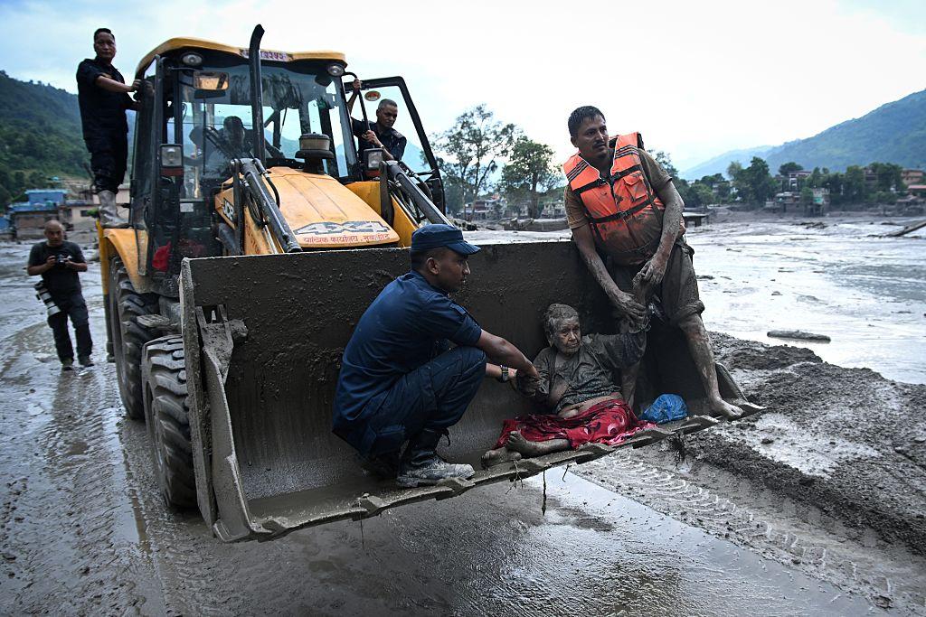
The 2026 floods caused widespread loss of life and major destruction across affected areas.
Nepal’s Ministry of Foreign Affairs reported on September 9 that 1,367 bodies had been recovered and around 5,100 people remained missing, while thousands of people had been rescued. The figures were described as subject to continuing updates as search and identification operations continued.
The disaster also damaged roads, bridges, hydropower projects, homes, and communications infrastructure.
Rescue operations were complicated by damaged roads, high river levels, unstable terrain, and difficult weather conditions.
The scale of the disaster meant that recovery would require more than simply clearing floodwater.
Entire transport and infrastructure networks needed repair.
The Hidden Danger of Himalayan Rivers
The story of the Nepal floods is also a reminder that rivers are connected systems.
A river beginning high in the Himalayas can cross enormous distances.
A sudden event near its source can affect communities far downstream.
The Trishuli eventually joins the Narayani system, which flows toward India where the river is known as the Gandak.
This means Himalayan disasters can have consequences that extend beyond a single valley or even a single country.
What Does the Nepal Flood Mystery Teach Us?
The disaster reveals a complicated relationship between mountains, glaciers, rivers, climate, geology, and human settlements.
It also demonstrates why the Himalayas must be understood as a connected environmental system.
The question is not simply:
“Why did the flood happen?”
The deeper questions are:
How stable are high-altitude slopes?
How quickly can glaciers and permafrost change?
How can rivers be monitored?
How quickly can warnings reach downstream communities?
And how should infrastructure be designed in areas exposed to rapidly changing mountain hazards?
These questions will become increasingly important as scientists continue studying the event.
The Roof of the World
The Himalayas have inspired people for centuries.
They appear timeless.
Immense.
Almost eternal.
But the 2026 disaster reminds us that even the world’s greatest mountains are constantly changing.
A glacier can collapse.
A river can rise by metres in minutes.
A temporary natural dam can become a deadly reservoir.
And an event that begins thousands of metres above sea level can transform communities far downstream.
The mountains did not suddenly become “savage.”
Rather, a complex combination of geology, ice, water, terrain, and changing environmental conditions created a cascading disaster.
And that is what makes the Nepal flood story so important.
It is not simply a story about one flood.
It is a story about how a changing mountain environment can affect people living far below it.
Final Thoughts
The 2026 Nepal floods began with a dramatic collapse high in the Himalayas.
A mass of glacier and rock descended toward a river.
The river was temporarily blocked.
The blockage failed.
Water and debris surged downstream.
And within a short time, communities along the river system were facing a catastrophic flood.
The full scientific picture will continue to develop as researchers study satellite imagery, geological evidence, glacier conditions, and the effects of long-term warming.
But one lesson is already clear:
In the Himalayas, what happens at the top of the mountain does not necessarily stay at the top.
A change thousands of metres above a valley can become a crisis for the people living below.
And the story of Nepal’s 2026 floods is a powerful reminder that the Roof of the World is alive, changing, and deeply connected to the lives of millions.
Explore More Documentaries
Discover more National Geo History documentaries about natural disasters, ancient civilizations, archaeology, lost cities, historical mysteries, and the forces that have shaped our world.
Subscribe to National Geo History and continue exploring the stories behind history, geography, and the changing world.





Leave a Reply